

Map showing present-day Sackville flooding in one-in-20-year storm (click to enlarge)
The New Brunswick government released maps today confirming that large parts of downtown Sackville are at severe risk of flooding.
The provincial maps show that, unless action is taken, the effects of climate change will increase the threat between now and the year 2100 both in the size of the areas flooded and the increasing depth of water.

Map showing 2100 Sackville flooding in one-in-20 year storm (click to enlarge)
The interactive maps, which allow viewers to make comparisons and even to check the risk to their own homes and businesses, show the effects of a much rarer, one-in-100 year storm both now and by 2100.
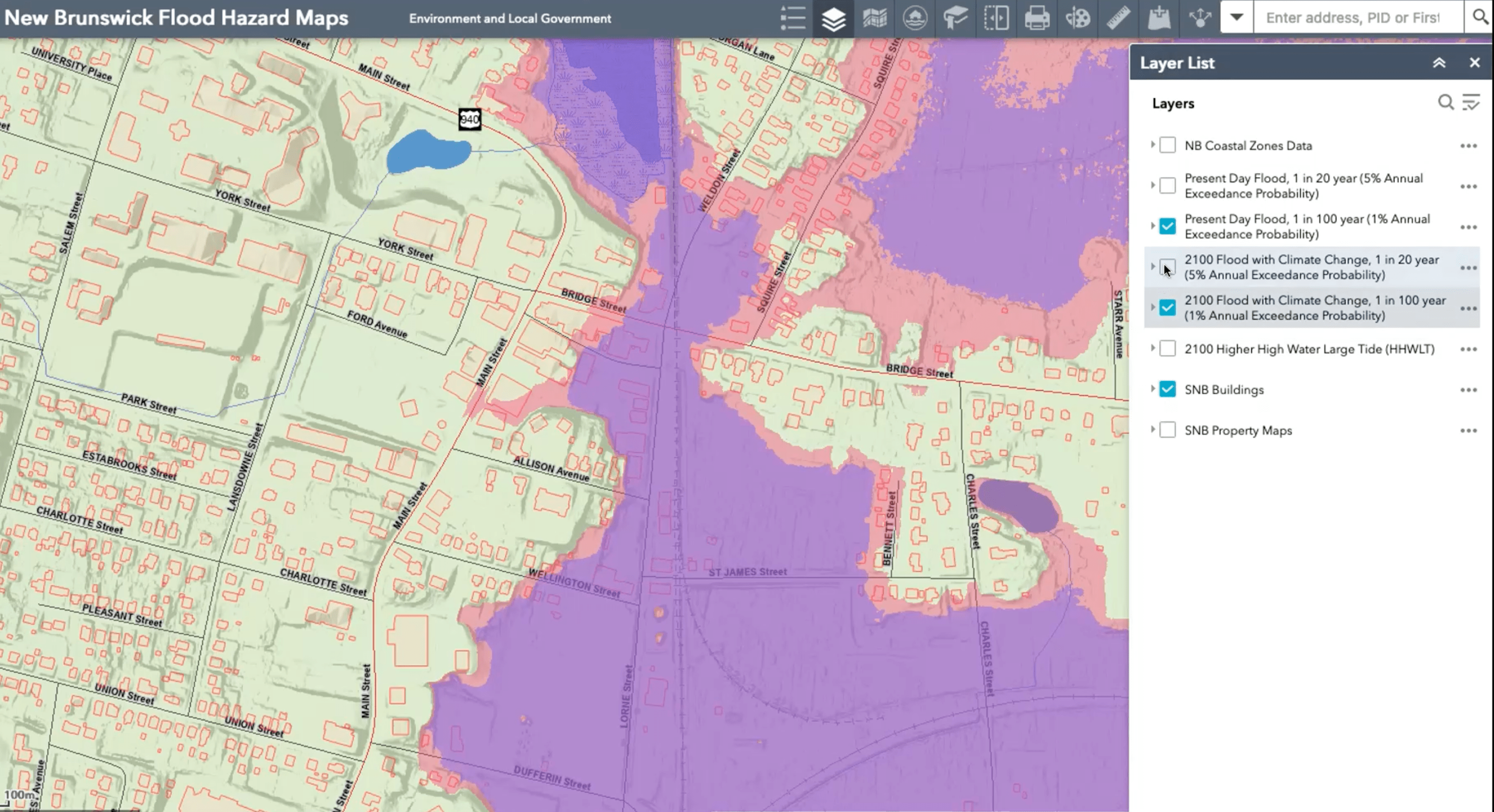
Map compares one-in-100 year storm in Sackville now (purple) and by 2100 (pink) (click to enlarge)
The maps also show there is risk of extensive flooding in Middle and Upper Sackville.

Sabine Dietz
Biologist and climate change expert Sabine Dietz says that although much of the information about flood risk was already known, the newly-released maps allow people to visualize the threat.
“It is scary,” she says.”I think the one thing that I’m just waiting for the Sackville community to come up in arms on this flood-risk map and say, ‘Why are you not doing anything for us?'”
Dietz, who serves as executive director of CLIMAtlantic Inc., a new research institute focusing on climate change in Atlantic Canada, is quick to add, however, that there’s no reason for panic because the maps will be a useful tool in deciding how to mitigate the threat over the next several decades.
“We’ve got to evaluate and assess the current risk,” she explains, “but this is for future planning…[and] what do we need to do in order to ensure that in 2100…that the decisions we make today as a province, as a community, that we are not putting people more at risk than they currently are.”
Dietz points out that Sackville faces what she calls a “double whammy” from inland, freshwater flooding as well as rising seas.
She notes that the province has yet to release a study on recommendations for protecting transportation, power and communications links on the Chignecto Isthmus.
To view the provincial, interactive flood risk maps, click here.
In my opinion there is no need for anyone to worry about any salt water or fresh water flooding here in Sackville, if the dyke system from Woodpoint over to Fort Beausejour is simply increased in height by three meters and a new gate structure is built at the mouth of the Tantramar River. It just needs MP Dominic LeBlanc, our Federal Minister of Infrastructure, to give the go-ahead.